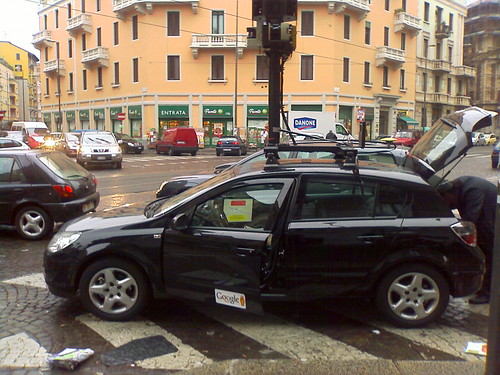
Some Google Street View cars were spotted in Italy this morning. Anyone who works in robotics will immediately notice the SICK laser scanners. It looks like we can expect 3D city data from Google sometime soon. Very interesting!
More pictures of the car here, here and here.
The cars have two side-facing vertical scanners, and another forward-facing horizontal scanner. Presumably they will do scan matching with the horizontal laser, and use that to align the data from the side-facing lasers to get some 3D point clouds. Typical output will look like this (video shows data collected from a similar system built by one of my labmates.)
The other sensors on the pole seem to have been changed too. Gone are the Ladybug2 omnidirectional cameras used on the American and Australian vehicles, replaced by what looks like a custom camera array. This photo also shows a third sensor, which I can’t identify.
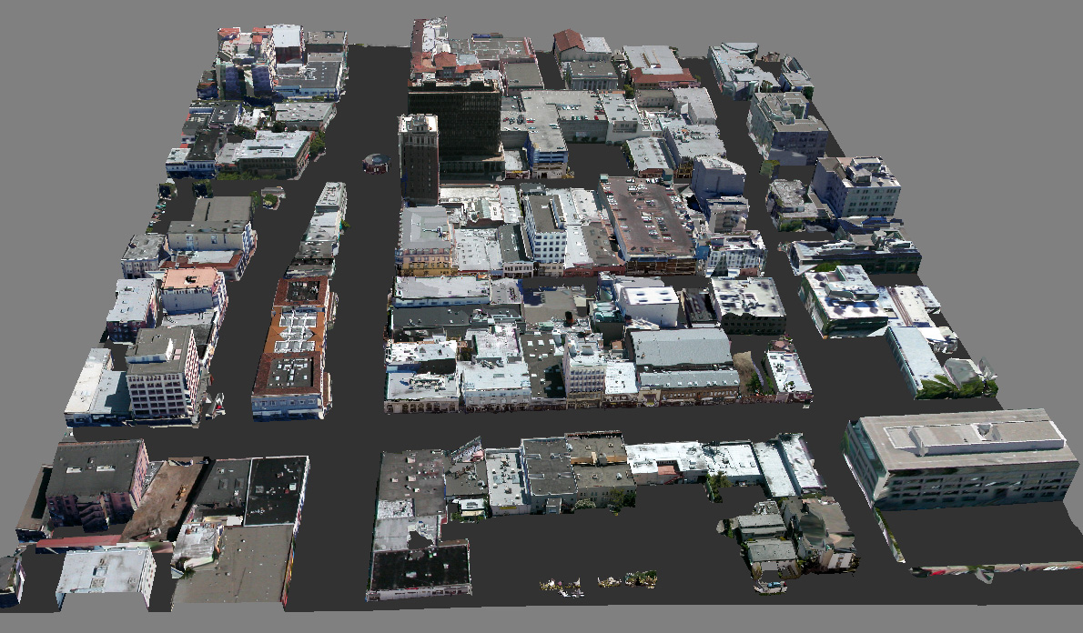
So, what is Google doing with 3D laser data? The obvious application is 3D reconstruction for Google Earth. Their current efforts to do this involve user-generated 3D models from Sketchup. They have quite a lot of contributed models, but there is only so far you can get with an approach like that. With an automated solution, they could go for blanket 3D coverage. For an idea of what the final output might look like, have a look at the work of Frueh and Zakhor at Berkeley. They combined aerial and ground based laser with photo data to create full 3D city models. I am not sure Google will go to quite this length, but it certainly looks like they’re made a start on collecting the street-level data. Valleywag claims Google are hiring 300 drivers for their European data gathering efforts, so they will soon be swimming in laser data.
Google aren’t alone in their 3D mapping efforts. Startup Earthmine has been working on this for a while, using a stereo-vision based approach (check out their slick video demonstrating the system). I also recently built a street-view car myself, to gather data for my PhD research. One way or another, it looks like online maps are headed to a new level in the near future.
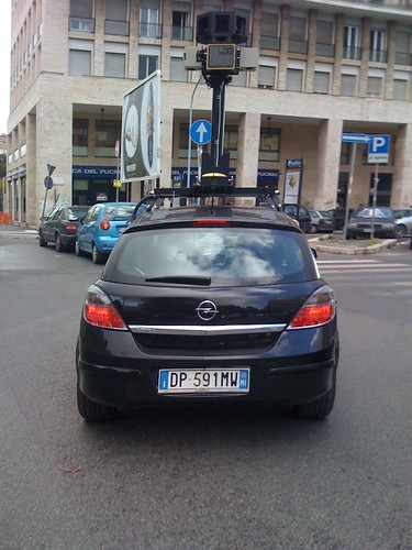
Update: Loads more sightings of these cars, all over the world. San Francisco, Oxford, all over Spain. Looks like this is a full-scale data gathering effort, rather than a small test project.
have you seen geosim? http://geosimphilly.com
Commenter FlagFreak over at Digital Earth Blog asks a good question:
This is definitely a problem. In the 3D model linked above, the system strips out all the foreground stuff, and then fills in the holes in the building façade by interpolation. Illustration here. As you can see in that example, the results aren’t perfect, but they’re not bad either.
3D reconstruction is definitely a really hard problem. There are many people currently doing PhDs on the subject. However, the Berkeley research demonstrates that it can be done pretty well for reasonably large examples. If anyone can make it work on an industrial scale, I’d put my money on Google.
http://www.everyscape.com is another company doing this. They seem to be using a system consisting of a mast containing conventional cameras. I say them in La Jolla,Ca last week. I have photo if anyone is interested.
Cheers
Tim
Now that will be some load of data!
http://streetviewgallery.corank.com
We’ve been using a combination of onfoot and vehicle based image capture systems to obtain still images of streets and Points of Interest. Our objective has been to then use the images (with embedded co-ordinates) for navigation (we supply images to Navman for use with their NavPix services) and location based services.
Out beta website (with 14,000+ images of London) just launched:
http://www.london5151.com
Hi Tim,
It’s always interesting to see more data. One of my favourite StreetView alternatives is MapJack, who have a system mounted on a bicycle. This lets them get data from areas that are off-limits to cars. I’m very impressed that they can fit a power supply, a camera array, a GPS and a computer into that little box on the back of the bike. They currently cover parts of California and some cities in Thailand.
Another new company called City8 has recently launched with good coverage in China. Take a look.
The same cars have also been spotted all over Spain. There were some sightings in San Francisco too (amusingly, being stopped by police :) )
It’s pretty clear this laser-based system isn’t a small experimental project, but a full-scale mapping effort. When Google decides to gather some data, it doesn’t mess about!
seen one yesterday in Turin
Just seen one on our Avenue in Bradford, West Yorkshire.
Given today (20 october 2008) in Udine (Friuli) Italy
Looks like it aint happening and was just a rouse to get attention which I never really believed for one mila second.
Cmon Google don’t go that route by intimating people we will rather not hear news at all then cryptic stuff that doesn’t tell us anything.
Good news is in quite a bit of areas at least in the USA they are redoing photos in High Definition so no more crappy 1985 cameras. :)
For tricky areas, Google now have a system mounted on a tricycle. Check it out. Not quite as economical as the MapJack bicycle, but not bad. There’s a little portable generator for power, looks like a Honda EU10i.
Hello – I just stopped by to say Happy Holidays
I have been searching for sites related to this. Glad I found you. Thanks
Comfortabl y, the post is in reality the best on this deserving topic. I harmonize with your conclusions and will eagerly look forward to your forthcoming updates. Just saying thanks will not just be sufficient, for the phenomenal lucidity in your writing. I will at once grab your rss feed to stay abreast of any updates. Good work and much success in your business efforts!
I have to say, I enjoy reading your post. Maybe you could let me know how I can bookmark it ? I feel I should let you know I found this site through yahoo.
jo blog, majd jovok ismet. :)
I really liked reading your post!. Quallity content. With such a valuable blog i believe you deserve to be ranking even higher in the search engines :) .
It’s interesting that Google is making an effort to make Google maps even better. I think with the Google Earth 3d, we won’t be needing much of asking directions from people nor should we really go to that certain place to see it. we just have to Google it!
Saw a similar post in a different blog. This time, they used a bicycle. I can’t wait to see what it would look like in 3d. I hope Google gets a greater coverage, especially those not so popular places.
Saw like this one on a different site. This time, they used a bicyle. I can’t wait to see how places look like in 3d. I hope Google gets a greater coverage and include places that are not so popular.
Generally I don’t post on blogs, however I would like to say that this post really pressured me to take action! really nice post.
When is this 3d thing available? I’d like to see the place where my bf currently works abroad.
Greetings, superb article.
Aside from Google, are there other companies doing this? And so has the best so far?
In the future google will be another part of daily human life.
my God, i thought you were going to chip in with some decisive insght at the end there
Thanks good post
bye bye.
important reading and awesome post. I will bookmark this website.
amazing blog post!
Cool, Thank you for info, #D Street view, is awsome!!!
Cool blog post, was curious if you would allow me to link to it in a article i am currently writing for my own website? Thanks Greg Wrobbel
Hey, if this website is ever nominated for an award just let me know so i can vote for ya?
Very informative post. Certainly a lot of useful information. Very happy I found your site. Will note it and return for more info.
all street cams are going to be 3D some day